

Slope and Landslide Monitoring Cases边坡与滑坡监测案例
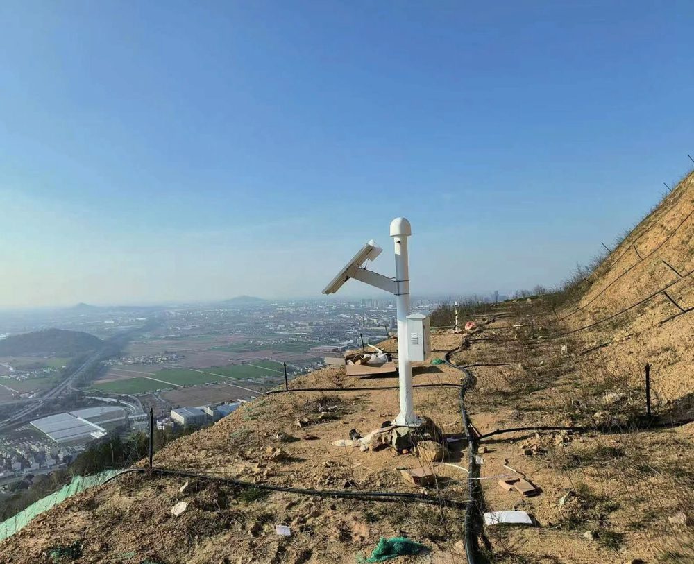
Slope monitoring needs surface displacement, deep slip-surface location, groundwater and rainfall in one warning logic. The standard stack is GNSS + flexible inclinometer + water level + rainfall, with solar and low-power communication for remote sites.边坡监测需要把地表位移、深部滑动面、地下水和降雨放进同一套预警逻辑。标准组合为 GNSS + 柔性测斜仪 + 水位计 + 雨量,配合太阳能和低功耗通信适应偏远现场。
Short baselines keep RTK stable; longer projects need multi-station or PPP planning.短基线更利于 RTK 稳定,长距离项目需提前规划多基站或 PPP。
Cloud logic should review link quality before treating a low fixed-solution rate as deformation.固定解比例低时需先复核链路质量,不能直接当作形变。
Solar power and low-power communication support remote slope stations.太阳能与低功耗通信支撑偏远边坡站点长期运行。
GNSS provides north-east-up displacement for landslide blocks and pipeline corridors.GNSS 输出滑坡体和管线走廊的三维地表位移。
What Rasber Monitors On Site瑞茨柏在现场监测什么
A slope warning system should not rely on one signal. GNSS tells whether the surface block is moving; flexible inclinometers reveal the depth and shape of internal deformation; water-level gauges explain groundwater-driven acceleration; rainfall and weather data provide triggering context. Rasber packages these into a low-power, solar-ready field system with quality flags for positioning reliability.边坡预警不能依赖单一信号。GNSS 判断地表块体是否移动,柔性测斜仪给出内部变形深度和形态,水位计解释地下水诱发加速,雨量与气象数据提供触发背景。瑞茨柏将这些组合成低功耗、可太阳能供电的野外系统,并对定位质量单独标记。
- ✓Surface and deep displacement together地表与深部位移联动
GNSS confirms block movement while flexible inclinometer profiles locate the active shear zone.GNSS 确认块体移动,柔性测斜曲线定位活动剪切带。
- ✓Water and rainfall as causes, not decoration水位和雨量是成因指标
Groundwater rise and rainfall history are displayed with displacement rate to support warning decisions.地下水抬升和降雨过程与位移速率同屏展示,用于支撑预警判断。
- ✓Communication quality before alarm先看通信质量再报警
For GNSS stations, fixed-solution rate and link logs are separated from displacement curves to prevent false warnings.GNSS 站点将固定解比例、链路日志与位移曲线分离,降低误报风险。
Monitoring Chain Used On Site现场监测链路
Delivered projects are organized from monitoring targets to data quality, alarm rules and reporting outputs.已交付项目从监测对象、数据质量、报警规则到报告输出形成完整链路。
Delivered Monitoring Cases已交付监测案例
These cases focus on monitoring targets, sensor combinations and the data logic used after delivery.以下案例重点展示监测对象、传感器组合和交付后的数据逻辑。
PetroChina Pipeline Geohazard Monitoring, Nanning中石油南宁管线地灾监测
Rasber served the Nanning PetroChina pipeline geohazard project, monitoring landslide-body deformation along an operating pipeline corridor without interrupting pipeline service.瑞茨柏服务中石油南宁管线地灾监测项目,在不影响在役管线运行的前提下,对管线走廊滑坡体变形开展监测。
Longyan High-Fill Slope Deformation and Bearing Test龙岩高填方边坡变形和承载力试验
Rasber used in-place inclinometer monitoring in the Longyan high-fill slope deformation and bearing-capacity test, where deep deformation is more meaningful than surface inspection alone.瑞茨柏在龙岩高填方边坡变形和承载力试验中应用固定式测斜监测。此类场景中,深部变形比单纯表面巡查更能反映风险。
Guizhou Xingyi Ring Expressway贵州兴义环城高速
Road-network slope projects connect geohazard monitoring with transport operation, requiring robust remote communication and maintenance-light deployment.路网边坡项目把地灾监测与交通运营安全连接起来,要求远程通信可靠、现场维护负担低。
Delivery Checks Behind Reliable Data可靠数据背后的交付检查
The following checks are standard items in field delivery and long-term operation.以下检查项是现场交付和长期运行中的标准动作。
| Delivery phase交付阶段 | Field check现场检查项 |
|---|---|
| Baseline planning基准规划 | Place GNSS base stations on stable ground; check baseline distance and sky visibility.GNSS 基准站必须设在稳定区域,核对基线距离和天空净空。 |
| Cross validation交叉验证 | Do not issue high-level warnings from GNSS alone when fixed-solution quality is poor.固定解质量差时,不仅凭 GNSS 位移发高级别预警。 |
| Field power野外供电 | Size solar panels for consecutive cloudy days plus reserve capacity.太阳能按连续阴雨天和安全冗余配置。 |
Planning a similar monitoring project?正在规划同类监测项目?
Send the site type, monitoring target, depth or span, power condition and reporting requirement. Rasber engineers will recommend a configuration based on delivered cases.提供现场类型、监测目标、孔深或跨度、供电条件和报告要求,瑞茨柏工程团队将结合已交付案例给出配置建议。